Featured Map for 24 May 2017:
California Highway 1 Severed in Big Sur
 Great circles conjure images of flying high above the planet on long trips,
yet there is much beauty to be seen from the ground, whether in the mountains
or close to sea level. Some of us are fortunate enough to live an easy drive
(hopefully in a fun car!) from the beauty of California's Big Sur;
many others have enjoyed a memorable visit to the area.
The Big Sur Visitor Bureau offers parachute coordinates but for most people
Californa Highway 1 is the easiest way to access Big Sur.
Great circles conjure images of flying high above the planet on long trips,
yet there is much beauty to be seen from the ground, whether in the mountains
or close to sea level. Some of us are fortunate enough to live an easy drive
(hopefully in a fun car!) from the beauty of California's Big Sur;
many others have enjoyed a memorable visit to the area.
The Big Sur Visitor Bureau offers parachute coordinates but for most people
Californa Highway 1 is the easiest way to access Big Sur.
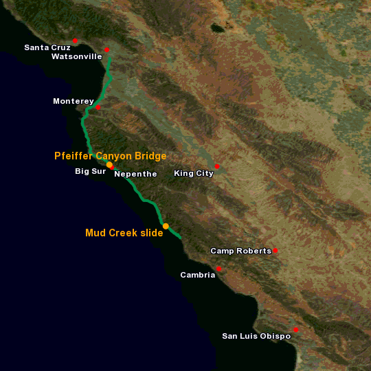
Or rather it was. Winter storms severely damaged the 49-year-old Pfeiffer Canyon Bridge near the town of Big Sur and the bridge was demolished on 18 March 2017. Yesterday, a huge landslide overran a large swath of the highway at Mud Creek, near the southern border of Monterey County. News sites have posted impressive videos of yesterday's landslide but haven't provided a good picture of where the landslide occurred.
Today's Featured Map shows the locations of the former Pfeiffer Canyon Bridge and the Mud Creek landslide (orange), the Monterey-County portion of CA 1 (green), and assorted airports and other landmarks for context. The map was generated offline because the path of the highway, based on U.S. Census Bureau data, contains more data than can be accommodated in a URL. Providing a convenient, web-based way to generate complex maps is under development; until then the map link excludes the path of the highway.
References and additional information:
- The Mercury News (San Jose)
- Massive landslide covers Highway 1 in southern Big Sur (23 May 2017)
- Cut off again, Big Sur visited only by helicopter (23 May 2017)
- Pfeiffer Canyon Bridge – Bridgehunter.com: Historic Bridges of the United States
- The Tribune (San Luis Obispo)
- How To Get Here – Big Sur Visitor Bureau
- Nepenthe Restaurant
- TIGER®/Line Shapefiles and TIGER®/Line Files – United States Census Bureau
|
Information on this site may not be accurate or current and is not valid for flight planning or navigation. No warranty of fitness for any purpose is made or implied. Flight planning and navigation should only be done using official charts.
Copyright © 2010-2024
Karl L. Swartz.
All rights reserved.
|