Featured Maps: Comparing SFO-ALB options (31 January 2010)
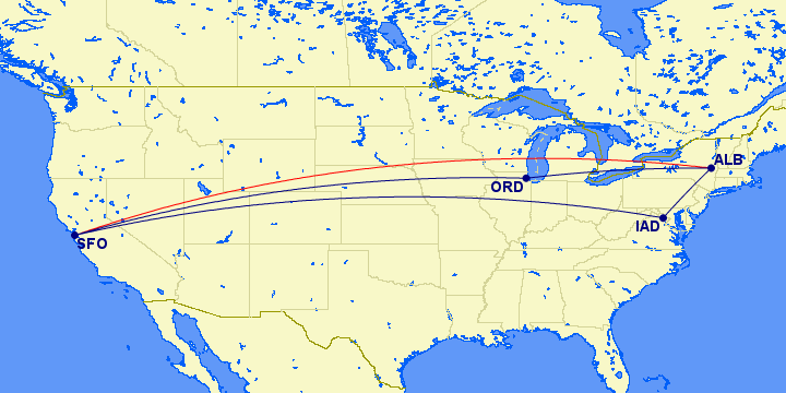
There are numerous Great Circle Mapper features designed to help certain groups of users, but which have never been documented clearly, if at all. Better documentation is coming, but for now the Featured Maps will occasionally be used to illustrate some of these features.For example, I'm in Albany, New York this weekend for a surprise party for my best friend's birthday. I flew on United (UA) so I had a choice of connecting at O'Hare or Dulles. An obvious question for GC Map is which is shorter, but almost is obvious is to ask how much the alternatives take you out of the way. Put another way, by how much do they exceed the non-stop distance?
The real data is in the Distances portion of the map map, and some people may even wish to skip the map by using the site's Distance function, but the map is a helpful sanity check. It also illustrates that you can include multiple paths on one map and that different paths on a map can use different colors.
Distances
From To Initial
HeadingDistance Actual
DistanceSFO (37°37'08"N 122°22'30"W) ALB (42°44'57"N 73°48'07"W) 66° (NE) 2559 mi 2559 mi 2 segment path: 2569 mi 2569 mi (+0.4%) SFO (37°37'08"N 122°22'30"W) ORD (41°58'51"N 87°54'24"W) 70° (E) 1846 mi 1846 mi ORD (41°58'51"N 87°54'24"W) ALB (42°44'57"N 73°48'07"W) 81° (E) 723 mi 723 mi 2 segment path: 2919 mi 2744 mi (+7.2%) SFO (37°37'08"N 122°22'30"W) IAD (38°56'51"N 77°27'36"W) 74° (E) 2419 mi 2419 mi IAD (38°56'51"N 77°27'36"W) ALB (42°44'57"N 73°48'07"W) 35° (NE) 500 mi 325 mi Total: 8047 mi 7872 mi
There are several things to note in the Distances summary:
- The first path was the non-stop (SFO-ALB).
- The additional paths have the same endpoints but include stops along the way. For these trips, the percentage increase in actual mileage relative to the non-stop is reported. Another non-stop path would reset the baseline from which the percentage increase was computed. Try adding SFO-LHR with and without a stop at LAX.
- I also added a minimum distance of 500 miles (and made sure statute miles were selected as the Disance Units) since that's the frequent flyer credit I get. Your mileage may vary!
I hope you will find some of these features useful when planning your own trips.
PS: I chose to fly via IAD both ways, mainly because I prefer a long
flight and a short one to two flights of intermediate length, though
the extra 350 frequent flyer miles each way didn't escape my notice.
|
Information on this site may not be accurate or current and is not valid for flight planning or navigation. No warranty of fitness for any purpose is made or implied. Flight planning and navigation should only be done using official charts.
Copyright © 2010-2024
Karl L. Swartz.
All rights reserved.
|